
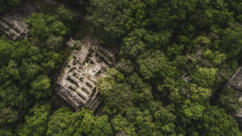
In 2022, archaeologist Richard D. Hansen led a team in Guatemala’s Mirador-Calakmul Karst Basin, where they made an incredible discovery. Spread over a 650-square-mile area, slightly larger than modern London, they found Mayan structures that had never been identified before. These 964 previously unknown sites, dating from 1000 B.C. to A.D. 150, were connected by 110 miles of raised causeways. This groundbreaking find challenged the assumption that tropical forest settlements were an obstacle to the development of complex societies. In a 2010 Archaeology article, Arlen Chase, Diane Chase, and John Weishampel wrote, “For too long, Maya archaeologists have been blinded by the jungle.” But thanks to the advancement of lidar technology, archaeologists are now able to map hidden ruins more accurately than ever before.
Lidar, short for light detection and ranging, was originally developed by NASA. Today, archaeologists are using this technology to map ancient ruins from above. Unlike traditional aerial photographs, lidar shoots lasers down from a drone, helicopter, or plane, creating highly detailed digital maps. This innovative approach allows the lasers to penetrate through the thick tree canopy, revealing precise topographic features that are difficult to observe with the naked eye. The use of lidar has enabled archaeologists to uncover new stories of human habitation and better understand the environmental changes that have occurred over time.
One remarkable example of lidar’s potential lies in the ancient city of Caracol in Belize. By utilizing lidar technology, researchers were able to map approximately 500,000 acres, providing a comprehensive view of the city’s layout and structure. In the past, the perception of tropical forests as impenetrable jungles devoid of complex civilizations has influenced archaeological investigations. However, the lidar-generated map of Caracol revealed the tallest man-made building in Belize, as well as monuments, houses, terraces, roads, causeways, and highways. This level of detail would have been nearly impossible to achieve without lidar, as manually plotting these points on the ground would have taken a lifetime.
Moreover, the use of lidar has revolutionized our understanding of ancient cultures and their interactions with tropical forests. It has challenged the notion that humans were simply surviving in these forests, instead demonstrating that they were thriving. For example, in the Amazon, archaeologist Heiko Prumers discovered extensive evidence of human-modified landscapes belonging to the Casarabe culture, which he refers to as “tropical low-density urbanism.” This concept was previously unknown and suggests that even in the dense rainforest, early civilizations were finding ways to adapt and transform their environment.
Archaeologist Patrick Roberts has also made significant discoveries regarding ancient human interactions with equatorial forests. His research in the Amazon and Southeast Asia has found evidence of nomadic people actively manipulating the forest for thousands of years. Through the analysis of fossilized pollen and seeds, researchers have uncovered evidence of controlled burns, revealing that humans were deliberately enriching the soil to encourage the growth of preferred trees. This level of complexity in ancient agricultural systems has been an eye-opener for archaeologists like Weishampel, who worked alongside the Chases.
Lidar technology has not only revolutionized our understanding of ancient forests but has also helped locate previously unknown ruins in various parts of the world. In Cambodia, lidar was instrumental in identifying the ruins of Mahendraparvata, an ancient city that will soon become a national park. Additionally, the mapping of Angkor Wat using lidar revealed that it was not an isolated ceremonial center, but rather a vast metropolis comparable in size to Berlin. In the Central African Rainforest, studies of tree species and pottery have challenged the perception that these forests were barren, demonstrating the complexity of human settlement and land use.
Overall, the application of lidar technology in archaeology has opened up new avenues of research and fundamentally transformed our understanding of ancient civilizations. From the identification of hidden ruins to unraveling the intricate relationships between humans and their environment, lidar has played a vital role in shaping our knowledge of the past. As researchers continue to explore and analyze data collected through lidar, it is clear that there is still much more to discover and learn about the ancient world.
